The change in the epistemology of land use can be viewed in terms of two phases: pre-liberalisation and post-liberalisation. In the pre-liberalisation phase, that is, the period starting from 1947-1991 the use of land was mainly confined to the use of agricultural, setting up of industries, and building up of dams. This period also saw the implementation of various land reform measures by the state like abolition of intermediary class, tenancy reform and land ceiling. These land reforms were implemented by the state mainly to ameliorate the menace caused by the colonial rule and to curb the exploitation of land by the zamindars and to ensure rights of the tenants. After the advent of liberalisation and globalisation, when structural reforms were introduced it altogether changed the conceptualisation of how land was perceived. Land from being an asset changed into an economic entity whose use became imperative for the building up of large industries, manufacturing hubs, Export Processing Zones (EPZs) and real estate townships. This phase also saw the enactment of Special Economic Zones Act (SEZ) 2005, where land and tax laws were diluted to make way for multinational companies (MNCs) and industrial units to set up exclusive zones mainly for the promotion of development and economic growth. This connotation of how development was inherited by the country caused a devastating change of how land garnered a dramatic shift in its use.
This earmarked change in the post-liberalisation phase caused a major overhaul in land-use and this was accompanied with the growth in urbanisation. As per the data recorded by the census of India (2011), the urban population have witnessed a dramatic shift in the population levels, from a mere 6.24 crores urban population in the year 1951 it has now surged to 37.71 crores in 2011. This linear expansion of urbanisation have induced land use change and these changes have been quiet rapid, abrupt and in most cases non-planned and have been a result of major disasters in the country. It has been estimated in the Global Assessment Report on Disaster Risk Reduction (2015) that the number of urban dwellers is expected to increase by 404 million over the next 35 years, which means that by 2050 approximately 50 per cent of India’s population will live in cities (p.227). This triggering of population growth as a result of urbanisation has been termed by the UNISDR report on Disaster Risk Reduction as “Tsunami of Urbanization”, this linear expansion of urbanization if unplanned is likely to result in a tsunami of disaster risk (UNISDR, 2015, p.2015).
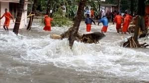
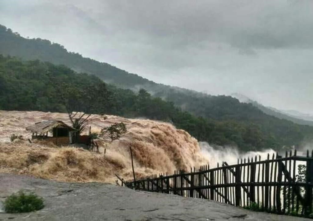
As per the land utilisation policy (2011), the number of towns in the country have increased from 5,161 to 7,935 and the number of urban agglomerations having a population of more than one million have increased from 5 in 1951 to 53 in 2011 (p.9). The accentuating demand of urbanisation has primarily led to creation of cities around hazard prone, fragile and environment sensitive areas, thus increasing the risk of disasters. The impact of land use change on disaster risk has also been encapsulated in the global framework of disaster risk reduction. The transition from Hyogo Framework for Action (2005-15) to Sendai Framework for Disaster Risk Reduction (2015-2030) has recognised land use as one of the overriding hazard in escalating the occurrence and impact of disasters across the globe. The HFA in its ten year agenda has conceded changing land use as one of the risk that escalates into disaster risk, therefore it is imperative to encourage sustainable use and management of ecosystems through better land-use planning and development activities to reduce risk and vulnerabilities (HFA 2005-15, p.13). The Sendai Framework for DRR which was adopted at the Third World Conference in Sendai, Japan has intertwined the need and promotion of sustainable management of land and its resources in its four priorities for strengthening disaster resilience which are namely, understanding disaster risk; strengthening disaster resilience governance; investing in DRR for resilience and lastly; enhancing disaster preparedness for effective response and build back better (Sendai Framework for DRR 2015-30, p.13). Sendai Framework has envisaged to promote the mainstreaming of disaster risk assessment into land use policy and ensure sustainable planning and management of land and its resources namely, mountains, rivers, coastal flood plain areas, drylands, wetlands, drought affected area and also preserving ecosystem functions that help to reduce risks (Sendai Framework 2015-30, p.18). Therefore, in order to check the menace caused by over exploitation of land which has caused destruction of forests, mangroves, coastal areas and wastelands, it is imperative to adopt a policy framework that intertwines disaster risk reduction along with sustainable land management.